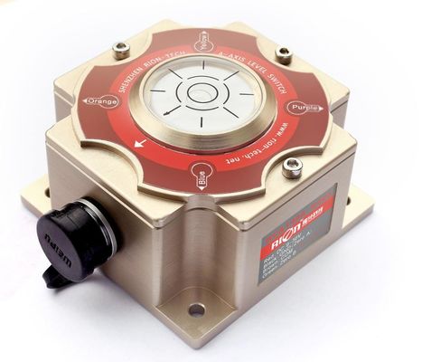


INS600 RTK INTEGRATED NAVIGATION SYSTEM.pdf
Inertial sensor with 2 GPS, IMU with 2 GPS, High performance INS, inertial navigation system
PRODUCTION EXECUTION STANDARD REFERENCE
○ Enterprise quality system standards: ISO9001: 2008 standard (certification number: 128101)
○ The intellectual property management system meets the standards: GB/T 29490-2013 (Certificate No.: 18117IP1529R0S)
○ High-tech enterprise (Certificate No.: GR201844204379)
○ China National Intellectual Property Appearance Patent (Patent No.: ZL 201730609544.2)
○ GJB 585A-1998 Inertia Technical Terminology
○ Software Development Reference Standard: GJB 2786A-2009 General Requirements for Military Software Development
○ Product environmental test standard: GJB150
○ Electromagnetic anti-interference test standard: GB/T 17626
▶ INTRODUCTION
The INS600 series is a dual-antenna GPS/INS integrated navigation system built by RION. The dual-antenna differential positioning measurement unit (IMU) is precisely calibrated in the full temperature to meet the performance requirements in different environments. The multi-data Kalman filter fusion algorithm is realized by a built-in navigation computer, and outputs real-time accurate carrier posture, heading information, three-dimensional position and velocity information, and various inertial device information. The appearance is exquisite, the structure is small, the installation is convenient, the use is flexible, and the operation is more stable and reliable.
▶ FEATURE
★ Gyro bias instability 10°/h (Allan Variance)
★ Accelerometer bias 1.7mg(within 4g range)
▶ APPICATION
★ Precision farming ★ Car navigation & measurement & control system
★ Surveying and mapping POS system ★ Ocean and underwater mapping
★ Industrial park unmanned vehicle ★ Ship and ocean engineering
★ High-speed train measurement and control system ★ Flight control
▶ PARAMETERS
| INS600 | |||
| System | Roll/pitch(1σ) | 0.2° | |
|
GPS loss-lock accuracy (vehicle-mounted CEP) |
Position drift(1km or 3min) | 0.2%,with odometer | |
| Heading drift (1min) | 0.15° | ||
| Gyro | Measuring range | 300°/s | |
|
Zero bias instability (Allen variance) |
10°/h | ||
|
Zero bias stability (1s smooth) |
15°/h | ||
| Zero bias repeatability | 15°/h | ||
| Full temperature zero bias | 0.1°/s | ||
| Scale factor nonlinearity | 200ppm | ||
| Scale factor repeatability | 200ppm | ||
| Resolution | <0.01°/s | ||
| Acceleration sensitivity | <0.0028°/s/g,rms all direction | ||
| Angle random walk | 0.15°/√hr | ||
| Bandwidth | 200Hz | ||
| Delay | <2ms | ||
| Accelerometer | Range | 4g | |
| Zero bias stability | 0.2mg | ||
| Full temperature zero bias | 1.7mg | ||
| Scale factor repeatability | 200ppm | ||
| Resolution | 0.1mg | ||
| Nonlinearity | 0.1% | ||
| Bandwidth | 200Hz | ||
| Satellite Navigation Board | Position(CEP) | 1.2m,2cm+1ppm(RTK) | |
| Speed(1s) | 0.03 m/s | ||
| Heading(1s) | 0.08°(base line 2m) | ||
| Frequency band | GPS L1,L2,L2C,Beidou B1,B2 | ||
| Interface | Input voltage | 12V | |
| Working current | 0.55A | ||
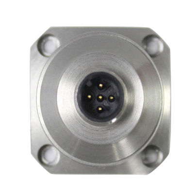
| Interface Type | 10 core aviation plug | ||
| Main engine | Size | 155*120*55mm | |
| Weight | 708g | ||
| Antenna | Size | 152*152*62.2mm | |
| Weight(single) | 433.5g | ||
| Data line | Size(length) | 5M | |
| Weight(single piece) | 30g | ||
▶ DIMENSION
![]()
▶ PIN DEFINITION
| Pin | Definition | Description |
| A | GND | Power ground |
| B | +12VDC | Power +(0.55A) |
| C | RS422_TX_N | RS422 send- |
| D | ||
| E | ||
| F | ||
| G | RS422_RX_P | RS422 receive+ |
| H | ||
| J | RS422_TX_P | RS422 send+ |
| K | RS422_RX_N | RS422 receive- |
![]()